
Explore Outside With These Foliage Maps
The autumn season brings many changes, but none are more spectacular than this: Billions of leaves are turning from green to auburn and gold. Because of all the variables at play, it can be tough to predict precisely when fall colors will peak, and how long they’ll last, in a particular area. But here’s an admirable effort:
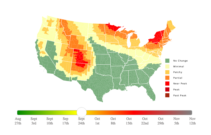
The website SmokyMountains.com created this interactive map to determine peak fall colors across the United States by county. You can slide the bar at the bottom of the map to see how the peak foliage spreads out across the country over the coming weeks. Use it to figure out the right time to do some leaf peeping in your area or on a weekend trip.
Different trees will reveal different colors, as the US Forest Service describes on its website. The leaves of oak trees, for example, turn reddish brown or russet. Here are a few others: Hickories: golden bronze, Aspen and yellow-poplar: golden yellow, Dogwood: purplish red, Beech: light tan, Sourwood and black tupelo: crimson, Red maple: brilliant scarlet, Sugar maple: orange-red, Black maple: glowing yellow, Striped maple: almost colorless
Our friends at Hipcamp also created a 2018 Fall Foliage Map that could help outdoor enthusiasts find the perfect destination with a new foliage filter to show the top campgrounds in the U.S. for enjoying the changing leaves (also using the data from Smokey Mountain)
While states like Vermont, New Hampshire, and Massachusetts are already known as hotspots for fall foliage, Hipcamp’s map also features campgrounds that might sometimes be overlooked. Think glamping accommodations in Wisconsin or an equestrian center in Colorado. There are also off-the-grid locations like hidden campgrounds in California, featuring private beaches, and Idaho campgrounds that offer views of the Grand Tetons.
Travelers should note the map is a prediction, and rainfall and temperatures can always change the exact dates when color peaks. Enjoy!